A hurricane is a powerful tropical cyclone that forms over warm ocean waters exceeding 80°F (27°C). These massive storm systems span up to 500 miles in diameter and reach heights of 50,000 feet, featuring sustained winds above 74 mph. Hurricanes rotate counterclockwise in the Northern Hemisphere and clockwise in the Southern Hemisphere, with a calm eye at the center. Understanding their complex structure reveals multiple hazards, including coastal flooding, tornadoes, and catastrophic wind damage.
Key Takeaways
- A hurricane is a powerful tropical storm system with sustained winds exceeding 74 mph and spanning up to 500 miles in diameter.
- Hurricanes form over warm ocean waters above 80°F, creating a low-pressure system with intense thunderstorms and cyclonic rotation.
- The storm features a calm eye surrounded by destructive winds, causing coastal flooding, inland flooding, and severe structural damage.
- In the Northern Hemisphere, hurricanes rotate counterclockwise, while in the Southern Hemisphere, they rotate clockwise.
- Hurricanes draw their energy from warm ocean waters, requiring temperatures above 26.5°C to a depth of 50 meters.
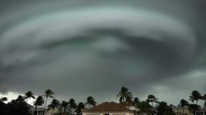
The Raw Power of Tropical Cyclones
A hurricane represents one of Earth's most formidable atmospheric phenomena, characterized by its immense size and destructive capabilities. These massive tropical cyclones can span over 500 miles in diameter and reach heights of 50,000 feet, generating sustained winds exceeding 74 mph.
Hurricane formation requires specific environmental conditions, including ocean temperatures above 26°C and minimal vertical wind shear. Once established, cyclone intensity manifests through multiple hazardous components. The Eastern Pacific season typically begins on May 15.
The system's counterclockwise rotation in the Northern Hemisphere (clockwise in the Southern) creates a powerful combination of high winds, torrential rainfall, and storm surge. The eye of the hurricane, though deceptively calm, is surrounded by the most intense weather conditions.
These storms pose numerous threats, including coastal flooding from storm surge, inland flooding from rainfall, structural damage from high winds, and the potential formation of tornadoes within the system's bands.
How Hurricanes Come to Life

Hurricanes originate exclusively over warm ocean waters where surface temperatures reach at least 80 degrees Fahrenheit, providing the essential thermal energy for storm development.
The initial stages commence when clusters of thunderstorms converge over these warm waters, creating an environment where warm, moist air rises and forms a low-pressure system.
This rising air mass initiates a self-reinforcing cycle where the system draws in additional warm air and moisture, allowing the storm to organize into a rotating structure that can intensify into a full-fledged hurricane that may span up to 600 miles across.
Storm Birth Over Water
Several precise conditions must align for a hurricane to form over ocean waters. The process requires ocean temperature of at least 80°F (27°C), which facilitates the rise of warm, moist air from the surface. This ascending air creates a low-pressure region near the surface, drawing in surrounding air masses and initiating hurricane formation.
Key elements for storm genesis include:
- Pre-existing atmospheric disturbance to focus convection
- Earth's Coriolis effect to generate rotation
- Continuous supply of warm, moist air
The development progresses as winds converge around the low-pressure center, forming clouds through condensation. As the system organizes, it establishes a rotating structure with increasing wind speeds. Heat energy absorption fuels the storm's growth as it pulls warmth from the ocean surface.
The storm continues intensifying until reaching tropical storm or hurricane status, characterized by a distinctive eye and surrounding eyewall of intense winds.
Warm Seas Feed Power
The process of hurricane formation relies fundamentally on warm ocean waters acting as a powerful energy source. Ocean temperatures exceeding 26.5 degrees Celsius to a depth of 50 meters provide the thermal conditions necessary for hurricane development.
As ocean currents transfer heat through these warm waters, they create the perfect environment for storm energy to build and intensify.
The interaction between warm seas and atmospheric conditions drives the hurricane's power system. When warm, moisture-laden air rises from the heated ocean surface, it creates areas of low pressure.
This process, combined with Earth's rotational forces, generates the characteristic cyclonic motion of hurricanes. The continuous supply of warmth and moisture from the seas below enables the storm to maintain and potentially increase its strength until landfall occurs.
Building Nature's Giant Force
Within Earth's dynamic atmosphere, powerful forces converge to build one of nature's most formidable weather systems through a complex sequence of meteorological events.
The hurricane anatomy begins with warm, moist air rising from ocean surfaces, creating instability and thunderstorms. Storm dynamics intensify as the Coriolis effect initiates rotation, while pressure differentials establish the system's structural foundation.
- Low-pressure zones form at the surface as rising air creates a cyclic pattern of vertical motion
- Counterclockwise rotation develops in the Northern Hemisphere, clockwise in the Southern Hemisphere
- System consolidation occurs as warm ocean waters fuel continued strengthening
The process culminates when winds exceed specific thresholds: 39 mph for tropical storm classification and 74 mph for hurricane status.
The system weakens rapidly upon encountering cooler waters or landfall, disrupting its primary energy source.
Inside the Eye of the Storm

Situated at the geometric center of every hurricane lies its distinctive eye, a deceptively calm region typically spanning 20-65 kilometers in diameter. This area exhibits clear skies, light winds, and sparse cloud cover, contrasting sharply with the surrounding violent conditions. The eye’s formation occurs when rising air in the eyewall forces inward, creating a warm, sinking environment with the storm’s lowest barometric pressure. While the eye offers a brief respite from the chaos outside, it is essential to understand that this tranquility is deceptive. As the storm progresses, the calm will be followed by a return to ferocious winds and heavy rain. Therefore, many people wonder, “is the eye of a hurricane safe? ” The answer is no; the eye is merely a fleeting moment of calm before the storm resumes its fury, making it crucial to stay alert and prepared throughout the entire event.
The eye's structure and dynamics reveal complex meteorological patterns. Surrounded by the eyewall's towering thunderstorms, the eye can vary dramatically in size, from merely 3.7 kilometers to an extensive 370 kilometers.
The eyewall demonstrates the notable stadium effect, where clouds curve outward with height. During storm evolution, the eye may undergo replacement cycles, forming concentric eyewalls that affect storm intensity.
Despite its peaceful appearance, the eye harbors dangers, including rogue waves from converging currents and sudden shifts to violent conditions upon entering the eyewall.
Measuring Nature's Fury

Moving beyond the hurricane's eye, scientists employ sophisticated measurement systems to quantify these powerful storms' destructive forces. The Saffir-Simpson Hurricane Scale categorizes storms based on sustained wind speed measurements taken at 33 feet above the water's surface, with categories ranging from 1 to 5.
Multiple measurement tools collaborate to provide extensive data:
- Satellite systems monitor ocean temperatures and storm intensity
- Hurricane Hunter aircraft deploy dropsondes to collect wind speed data
- Ground-based Doppler radar and oceanic buoys track storm progression
Significant measurement challenges persist due to hurricanes' vast size and dynamic nature. Satellites provide estimates but may lack precision, while aircraft measurements might not capture peak wind speeds.
Despite these limitations, accurate data remains essential for predicting potential damage and coordinating emergency responses. The combination of various measurement technologies helps meteorologists monitor these powerful storms and issue timely warnings to protect vulnerable populations.
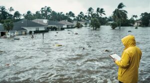
When Mother Nature Strikes

The raw power of a hurricane releases multiple destructive forces when making landfall. As the eyewall crosses the coastline, the storm's interaction with terrain initiates a complex sequence of impacts, including storm surge, intense winds, and flooding rains.
These elements can cause widespread devastation to coastal communities and inland regions alike.
Hurricane preparedness becomes essential when conditions indicate an approaching storm. The National Weather Service implements a structured warning system, providing vital time windows for safety measures.
Watches issued 48 hours before potential threats and warnings declared 36 hours before expected hurricane-force winds enable systematic preparation procedures. Storm safety protocols emphasize the importance of acting before tropical storm-force winds begin.
The distinction between landfall and a direct hit remains operationally significant, as dangerous conditions can affect areas near the storm's center even without technical landfall.
This understanding guides emergency response strategies and evacuation procedures.
The Science of Hurricane Tracking

Modern hurricane tracking integrates an array of sophisticated technologies and methodologies to monitor and predict tropical cyclone behavior. The National Hurricane Center employs satellite technology alongside hurricane hunters to gather real-time data on wind speeds, pressure, and storm structure.
Advanced hurricane prediction models combine numerical forecasting with statistical methods to analyze storm patterns and potential trajectories.
Key components of hurricane tracking include:
- GIS systems integrating satellite imagery, radar data, and topographic information
- Doppler radar monitoring storm intensity and movement patterns
- AI-enhanced forecasting models like Pangu-Weather for improved accuracy
The implementation of machine learning techniques has revolutionized data processing capabilities, enabling more precise storm classification and rapid intensification prediction.
This technological framework allows for thorough storm monitoring through a network of ocean buoys, reconnaissance aircraft, and weather satellites, creating a robust system for hurricane tracking and public safety preparation.
The Benefits Of Consulting A Public Adjuster

Public adjusters serve as specialized insurance professionals who provide objective assessments of hurricane damage while advocating for policyholders during the claims process.
Their expertise in insurance policies and documentation requirements helps maximize claim settlements through thorough evaluations of both visible and hidden property damage.
The involvement of a public adjuster typically results in more efficient claims processing and higher settlement amounts compared to policyholder-managed claims.
Studies have shown that hurricane claims with settlement increases up to 800% are possible when working with qualified public adjusters.
Expertise In Insurance Claims
While managing complex insurance claims after hurricane damage can overwhelm property owners, consulting a public adjuster offers significant advantages for maximizing settlement outcomes.
These professionals possess extensive knowledge of insurance policy nuances and employ proven claim negotiation strategies to advocate for policyholders. Their expertise enables thorough documentation of both visible and concealed damage, ensuring detailed claim assessment and fair compensation.
Operating on commission-based fee structures, public adjusters are incentivized to secure the highest possible settlements for their clients.
- Specialized understanding of policy terminology and coverage limitations
- Advanced techniques for identifying and documenting hurricane-related damages
- Strategic negotiation methods for resolving disputes with insurance carriers
Public adjusters streamline the claims process through meticulous documentation and effective communication with insurers.
Their professional knowledge of industry practices and claim procedures helps expedite settlements while ensuring policyholders receive appropriate compensation for hurricane-related losses.
Objective Damage Assessment
Accurate damage assessment following hurricanes requires sophisticated methodologies that combine traditional inspection techniques with advanced technologies. Remote sensing through satellite imagery enables rapid evaluation of structural damage by comparing pre- and post-hurricane building footprints. Machine learning models, particularly convolutional neural networks, classify damage levels from undamaged to destroyed, enhancing assessment precision.
Public adjusters complement technological approaches by conducting detailed on-site evaluations, documenting both visible and concealed hurricane damage. These professionals gather evidence, prepare thorough reports, and negotiate with insurance companies to guarantee fair compensation.
While public adjusters typically charge contingency fees, their expertise in damage assessment often leads to maximized settlements. For cases involving coverage disputes or claim denials, policyholders may need to consult insurance claims attorneys for legal intervention. Maintenance records can significantly strengthen hurricane damage claims by establishing the pre-storm condition of the property.
Streamlined Claim Process
Engaging a public adjuster for hurricane damage claims delivers significant advantages through a streamlined process that maximizes efficiency and settlement outcomes.
This professional approach enhances claim efficiency through automated administrative tasks and expert policy interpretation, while providing extensive policyholder support throughout the recovery period. Public adjusters leverage their industry knowledge to expedite settlements and minimize processing delays.
- Technical expertise in policy analysis and documentation requirements accelerates claim resolution
- Personalized advocacy guarantees thorough damage assessment and maximum settlement potential
- Professional management reduces policyholder stress while maintaining compliance standards
The streamlined approach transforms complex claim procedures into manageable processes, allowing property owners to focus on recovery while experts navigate insurance negotiations.
This systematic methodology optimizes outcomes through professional guidance, detailed documentation, and strategic claim presentation.
Operating on contingency fee basis, public adjusters typically charge between 5-20% of the final settlement amount while delivering specialized knowledge that often yields more favorable outcomes.
Higher Claim Payouts & Settlements
Professional representation by public adjusters consistently leads to higher claim payouts and more favorable settlements for hurricane-damaged properties.
Through thorough damage assessments and detailed documentation, these experts identify all forms of property damage, including hidden issues that property owners might overlook. Their claim strategies encompass thorough evidence collection and expert policy interpretation.
Public adjusters leverage their extensive knowledge of insurance policies to advocate effectively for maximum compensation.
Their expertise in identifying complex damage patterns and understanding coverage nuances enables them to build stronger cases for higher payouts.
Statistics show that less than 5% of policyholders are even aware that public adjusters exist to help them navigate complex insurance claims.
About The Public Claims Adjusters Network (PCAN)

Public adjusters serve as essential advocates in the complex landscape of insurance claims, forming networks and associations to enhance their collective effectiveness.
These professionals operate within established networks to maximize claim settlements through shared expertise and resources. Their collaborative approach guarantees policyholders receive thorough support throughout the claims process, leveraging collective experience to navigate complex insurance policies.
Public adjuster roles within these networks focus on delivering ideal outcomes through systematic claim management and professional representation. By working collectively, they maintain high standards of service while providing access to extensive industry knowledge and proven methodologies for claim settlement.
- Networks provide access to specialized expertise across various types of property damage claims
- Members benefit from shared resources, including advanced assessment tools and documentation systems
- Collaborative partnerships enable rapid response capabilities during catastrophic events, guaranteeing timely assistance for policyholders
These structured networks enhance the ability of public adjusters to serve their clients effectively while maintaining professional standards and operational excellence.
Frequently Asked Questions
Why Are Hurricanes Given Names?
Hurricane naming evolved from historical significance, providing clear identification of multiple storms simultaneously, enabling effective communication among meteorologists, emergency services, and the public for tracking and warning purposes.
Can Two Hurricanes Merge Together?
Through the Fujiwhara Effect, hurricane fusion can occur when two systems interact. This weather phenomena typically results in the stronger storm absorbing the weaker one, though complete mergers are rare.
What Is the Deadliest Hurricane Ever Recorded?
Like a devastating force of nature released, the Great Hurricane of 1780 stands as history's deadliest recorded hurricane, claiming approximately 22,000 lives across Martinique, Barbados, and St. Eustatius.
How Long Can Hurricanes Last?
Hurricane duration typically ranges from 7-14 days, though some storms persist longer. The storm lifecycle depends on warm ocean waters, with the longest recorded Atlantic hurricane lasting 28 days in 1899.
Do Hurricanes Occur in Other Parts of the World?
Globally, 80-90 tropical cyclones form annually across seven major basins worldwide. These storms manifest as hurricanes, typhoons, and cyclones, creating significant global impact from the Atlantic to the South Pacific regions.
References
- https://study.com/learn/lesson/hurricane-formation-characteristics.html
- https://www.youtube.com/watch?v=_cUbV-zPDr8
- https://wp.stolaf.edu/cila/files/2020/09/Teaching-at-Its-Best.pdf
- https://oceanservice.noaa.gov/facts/hurricane.html
- https://bkvenergy.com/blog/how-do-hurricanes-form/
- https://ghrc.nsstc.nasa.gov/home/micro-articles/hurricane
- https://scijinks.gov/hurricane/
- https://www.weather.gov/source/zhu/ZHU_Training_Page/tropical_stuff/hurricane_anatomy/hurricane_anatomy.html
- https://www.earthnetworks.com/blog/what-is-a-hurricane/
- https://www.mauicounty.gov/691/Hurricane-Characteristics