Hurricanes require ocean temperatures above 26.5°C (80°F) to form and can generate winds exceeding 157 mph. These tropical cyclones feature a calm eye spanning 20-50 kilometers in diameter, surrounded by violent eyewall winds. Approximately 80% of major hurricanes undergo rapid intensification, potentially increasing wind speeds by 35 mph within 24 hours. Storm surges can begin 24 hours before landfall, while space-based monitoring revolutionizes tracking capabilities. The complex interplay of atmospheric and oceanic factors reveals fascinating meteorological dynamics.
Key Takeaways
- A hurricane's eye diameter typically ranges from 20-50 kilometers and features calm conditions despite surrounding violent winds.
- Hurricanes require ocean waters above 26.5°C (80°F) to form and maintain their strength.
- 80% of major hurricanes undergo rapid intensification, with wind speeds potentially increasing by 35 mph within 24 hours.
- Storm names are permanently retired when hurricanes cause significant damage or loss of life.
- Hurricanes quickly lose strength after landfall due to loss of warm ocean water energy, typically weakening within 24 hours.
The Eye: Nature's Calm Within Chaos
While tropical cyclones are characterized by their violent winds and destructive force, the eye at their center presents a remarkable contrast of atmospheric calm. Typically spanning 20-50 kilometers in diameter, these distinctive eye characteristics include clear skies and relatively light winds, resulting from the Coriolis force deflecting winds around the center.
Eye formation occurs when rising air in the eyewall moves toward the center, creating a warming effect through subsidence. The process removes diabatic heating from the storm's center, leading to rapid intensification when a persistent eye develops. During hurricane conditions, the lowest pressures are found within the eye region.
Eye variations range considerably, from clear to cloud-filled configurations, with sizes spanning from 3.7 to 370 kilometers across. Pinhole eyes, which are extremely small and circular, often indicate intensifying systems, while large, irregular eyes suggest weakening conditions.
Eye dynamics can involve secondary eyewall formation, particularly in intense tropical cyclones with winds exceeding 33 m/s, frequently leading to eyewall replacement cycles that temporarily weaken the storm.
Global Names for Nature's Giants

To facilitate precise identification and tracking of tropical cyclones worldwide, the World Meteorological Organization (WMO) maintains a standardized naming system that varies by geographical basin. The naming conventions incorporate cultural sensitivity while ensuring clear communication across international boundaries.
| Region | Primary Naming Authority | Cycle Pattern | Notable Features |
|---|---|---|---|
| Atlantic | WMO | 6-year rotation | Alphabetical, alternating male/female names |
| NW Pacific | Japan Met Agency | Sequential list | International contributor system |
| Philippines | PAGASA | Local names | Additional regional designation |
| Indian Ocean | Regional centers | Annual lists | Basin-specific nomenclature |
Each basin follows distinct protocols, with names systematically retired when storms cause significant damage or loss of life. The Northwest Pacific designates these systems as typhoons, while the Indian Ocean uses the term cyclones. When these powerful storms reach land, they often create storm surges up to 6 meters high along coastal areas. This standardization enables meteorologists to track multiple systems simultaneously while maintaining precise documentation of their characteristics and trajectories.
Breaking Down the Hurricane Categories

The Saffir-Simpson Hurricane Wind Scale classifies tropical cyclones into five distinct categories based on sustained wind speeds ranging from 74 mph to over 157 mph.
Each ascending category correlates with exponentially increasing destructive potential, from Category 1's minimal structural damage to Category 5's catastrophic devastation of entire regions.
The classification system provides emergency managers and meteorologists with standardized metrics to assess potential hurricane impacts on infrastructure, vegetation, and storm surge expectations. Major hurricanes begin at Category 3, with sustained winds of at least 111 mph and the potential for devastating structural damage.
Understanding Wind Speed Ranges
Modern meteorological classification systems rely on the Saffir-Simpson Hurricane Wind Scale to categorize hurricanes into five distinct intensity levels based on sustained wind speeds.
The scale begins with Category 1 hurricanes, exhibiting winds of 74-95 mph, capable of producing minimal structural damage. Category 2 storms range from 96-110 mph, while Category 3 hurricanes intensify to 111-129 mph, marking the threshold for major hurricanes.
Category 4 systems generate devastating winds of 130-156 mph. The most extreme classification, Category 5, encompasses storms with winds exceeding 157 mph. Wind speed impacts escalate considerably with each category, necessitating specific hurricane preparedness tips for different intensity levels.
Measurements are taken at 10 meters above the surface using one-minute sustained wind averages, providing standardized data for meteorological analysis. The scale underwent a significant update in 2009 structural revision to focus exclusively on wind speeds as the primary classification factor.
Storm Damage By Category
Intensifying wind speeds across hurricane categories correlate directly with progressively severe structural and environmental damage patterns.
Category 1 storms typically cause minimal damage to buildings and brief power outages, while Category 2 hurricanes escalate storm impact through significant roof damage and extended utility disruptions.
Hurricane preparedness becomes critical for Category 3-4 events, where structural failures emerge alongside extensive environmental destruction, including widespread tree damage and potential coastal inundation from storm surge reaching 18 feet.
Category 5 hurricanes represent the apex of destructive potential, characterized by catastrophic structural collapse, complete building failure, and storm surge exceeding 18 feet. Rural communities face particular vulnerability during major hurricanes, often becoming completely cut off due to infrastructure destruction.
This highest classification necessitates thorough evacuation protocols for coastal regions, with power infrastructure disruptions potentially extending for months post-storm.
How Warm Waters Feed These Monster Storms

The process of hurricane intensification relies on a continuous transfer of thermal energy from warm ocean waters to the developing storm system.
As sea surface temperatures exceed 80°F (27°C), the rate of evaporation and subsequent heat exchange accelerates, creating a self-reinforcing cycle of rising warm air masses and decreasing atmospheric pressure.
This oceanic heat transfer mechanism sustains the storm's energy cycle, with warmer waters providing more fuel for increased wind speeds and enhanced convective activity within the hurricane structure. This pattern has intensified in recent decades, as rapid hurricane intensification has become more common since the 1980s.
Ocean Heat Transfer Process
Ocean heat transfer mechanisms form the vital foundation of hurricane development and intensification. As hurricanes traverse warm waters, they initiate complex interactions between atmosphere and ocean, driving heat exchange through evaporation and vertical mixing.
Strong surface winds generate ocean currents that facilitate both upward and downward heat distribution, with warm surface waters being pushed deeper while cooler subsurface waters rise through upwelling. The thickness of the oceanic mixed layer varies significantly between regions like the Gulf of Mexico and Caribbean Sea, affecting how storms interact with ocean waters.
This dynamic process affects hurricane behavior in two vital ways. Initially, warm surface waters provide essential thermal energy through evaporation, fueling storm development.
However, the subsequent mixing can lead to surface cooling, potentially limiting storm intensity. The displaced heat doesn't disappear but rather becomes sequestered in deeper ocean layers, where it can influence long-term climate patterns and future storm formation potential.
Intensifying Storm Energy Cycles
Powerful heat-driven processes underlie the rapid intensification of tropical cyclones, particularly in regions experiencing marine heat waves.
Storm energy accumulates considerably when warm ocean waters interact with atmospheric conditions, creating a self-reinforcing cycle of intensification factors. The Loop Current's transportation of tropical waters provides substantial thermal energy, while subsurface ocean heat content further amplifies this process. These conditions are expected to worsen as global warming strengthens the influence of marine heat waves on hurricanes.
Statistical data indicates that intensification rates have increased markedly, with 80% of major hurricanes now undergoing rapid intensification.
Key regions like the Cayman Basin and Bay of Campeche demonstrate up to five times greater risk of accelerated development.
When sea surface temperatures exceed typical thresholds, the continuous cycle of rising warm air and inward-flowing replacement air can trigger a 35-mile-per-hour increase in maximum wind speeds within 24 hours.
The Record-Breaking Typhoon Tip

Devastating Typhoon Tip, which formed near Pohnpei on October 4, holds multiple meteorological records as the most intense and largest tropical cyclone ever recorded. The system's formation was initially constrained by a nearby tropical storm before rapid intensification occurred past Guam. The U.S. Air Force conducted sixty reconnaissance flights to monitor this extraordinary storm.
Upon reaching peak intensity, Tip achieved an unprecedented low pressure of 870 millibars with sustained winds of 305 kilometers per hour.
The cyclone's extraordinary dimensions included a diameter of 2,220 kilometers, approximately half the size of the continental United States, with gale-force winds extending 1,100 kilometers from its compact 15-kilometer-wide eye.
Tip's impact on Japan proved catastrophic, triggering over 600 mudslides and flooding 22,000 homes. The system claimed 44 maritime casualties and resulted in a devastating incident at Camp Fuji, where 13 Marines perished.
Transportation infrastructure suffered severe disruption, with hundreds of trains and flights canceled, culminating in damages exceeding $100 million.
Different Spins Across the Equator

The Coriolis effect, a consequence of Earth's rotation, creates distinct rotational patterns in tropical cyclones across hemispheres.
Northern Hemisphere hurricanes rotate counterclockwise due to rightward deflection of air masses, while Southern Hemisphere systems exhibit clockwise rotation from leftward deflection.
This hemispheric distinction is fundamental to hurricane formation and behavior, with the effect becoming negligible near the equator, preventing cross-equatorial migration of developed tropical systems. The rare formation of Typhoon Vamei in 2001 demonstrated that storms could develop unusually close to the equator under exceptional circumstances.
Coriolis Effect's Global Impact
Due to Earth's rotational forces, a meteorological phenomenon known as the Coriolis effect considerably influences tropical cyclone formation and rotation across different hemispheres.
This global influence manifests through distinct rotational patterns and geographical constraints on storm development.
The Coriolis influence directly impacts storm paths and formation in three primary ways:
- Northern Hemisphere cyclones rotate counterclockwise, while Southern Hemisphere systems rotate clockwise.
- Tropical cyclones cannot form within 5 degrees of the equator due to insufficient Coriolis force.
- Storm systems gain rotational momentum as they move away from the equator, where the Coriolis effect strengthens.
These meteorological systems, whether termed hurricanes, typhoons, or cyclones, develop over warm ocean waters and are steered by trade winds, with their trajectories modified by the Coriolis effect's hemispheric influence.
Storm Rotation By Hemisphere
While global storm formation follows consistent meteorological principles, rotational dynamics manifest distinctly across Earth's hemispheres, creating mirror-image circulation patterns in tropical cyclones. The Coriolis effect fundamentally influences hurricane spin, generating counterclockwise rotation in the Northern Hemisphere and clockwise rotation in the Southern Hemisphere. These atmospheric dynamics operate on massive scales, directing air movement from high to low-pressure systems.
| Characteristic | Northern Hemisphere | Southern Hemisphere |
|---|---|---|
| Rotation Direction | Counterclockwise | Clockwise |
| Wind Deflection | Right-curved | Left-curved |
| Pressure Flow | High to low | High to low |
| Formation Zone | North of equator | South of equator |
| Storm Structure | Eye wall surrounds center | Eye wall surrounds center |
This hemispheric differentiation remains constant regardless of storm intensity or seasonal variations, maintaining these distinct rotational signatures throughout their lifecycle.
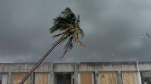
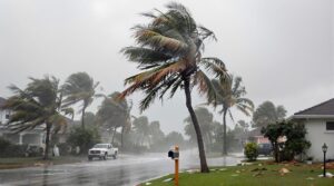
Why Hurricanes Die on Land

Powerful hurricanes rapidly lose their characteristic intensity once making landfall, primarily due to the cessation of their primary energy source: warm ocean waters.
When hurricane energy shifts from oceanic to terrestrial environments, the storm undergoes significant structural modifications due to land interaction. The storm's decay accelerates through multiple mechanisms, including increased surface friction and disruption of its moisture supply.
Three primary factors contribute to hurricane dissipation over land:
- Termination of warm ocean water evaporation (>80°F), which disrupts the storm's secondary circulation
- Enhanced surface friction from terrestrial features, causing rapid wind field deterioration within hundreds of meters inland
- Environmental interactions with dry air masses and vertical wind shear, leading to structural degradation
The process of decay typically manifests within 24 hours of landfall, though the hurricane's wind field may paradoxically expand during weakening, potentially increasing storm surge risks despite diminishing maximum wind speeds.
Watching Storms From Space

Since the advent of space-based observation platforms, meteorological monitoring of tropical cyclones has revolutionized hurricane tracking and forecasting capabilities.
From 400 kilometers above Earth, the International Space Station provides unprecedented views of these powerful storms, as demonstrated during observations of Hurricane Helene in September 2024.
Space observations utilize multiple satellite systems, including NASA's Terra satellite with its MODIS instrumentation and the DSCOVR satellite's EPIC camera, which captures natural-color imagery from 1.5 million kilometers away.
These platforms enable scientists to analyze critical parameters such as sea surface temperatures and ocean heat content, which directly influence hurricane intensity.
The ISS and other orbital platforms document hurricane formation processes, from the initial warm air convection near the equator to the characteristic rotation patterns influenced by Earth's spin.
This extensive monitoring network enhances understanding of cyclone behavior and supports accurate tracking of storm development, movement, and potential impact zones.
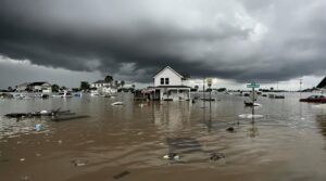
The Power of Storm Surges

Among the most lethal components of a hurricane, storm surges represent an abnormal rise in ocean water that can inundate coastal regions with devastating force. These powerful oceanic phenomena, driven by intense wind action and low atmospheric pressure, can extend over 150 kilometers inland, creating catastrophic flooding conditions when combined with astronomical tides and rainfall.
Storm surge impacts manifest in several critical ways:
- Physical force: Water masses weighing approximately 1,700 pounds per cubic yard can demolish structures and transport large objects inland.
- Rapid inundation: Flooding can begin up to 24 hours before hurricane landfall.
- Compound effects: Integration with high tides creates storm tides, amplifying destructive potential.
Storm surge forecasting presents significant challenges due to multiple variables, including cyclone characteristics, coastal topography, and timing relative to tidal cycles.
The complexity of these interactions requires sophisticated modeling systems to predict surge heights and potential inland penetration, essential data for evacuation planning and emergency response coordination.
The Science Behind Hurricane Formation

When atmospheric and oceanic conditions converge precisely, tropical cyclogenesis initiates the complex process of hurricane formation. The fundamental requirement involves ocean waters exceeding 26.5°C (80°F), which facilitates rapid evaporation and establishes the critical energy transfer mechanism necessary for storm development.
Hurricane dynamics rely on a self-sustaining feedback loop where warm, moisture-laden air rises, creating zones of low atmospheric pressure. This process triggers the inflow of surrounding air masses, while the Coriolis force, absent within 5 degrees of the equator, imparts the characteristic rotational motion.
The system intensifies as water vapor condenses in the rising air columns, releasing latent heat that further fuels the storm's development.
For successful hurricane formation, environmental parameters must include minimal vertical wind shear, elevated relative humidity throughout the troposphere, and a saturated lapse rate gradient near the circulation center.
These conditions, combined with sustained oceanic heat flux, enable tropical disturbances to evolve into mature hurricane systems.
About The Public Claims Adjusters Network (PCAN)

In the aftermath of severe weather events like hurricanes, the Public Claims Adjusters Network (PCAN) operates as a specialized consortium of licensed insurance professionals who systematically assess and process storm-related damages.
These industry experts utilize standardized claim management protocols while adhering to strict professional standards across 45 states and the District of Columbia.
PCAN's operational framework includes:
- Deployment of emergency response units for rapid damage assessment and mitigation
- Implementation of thorough documentation procedures for maximum claim recovery
- Execution of strategic negotiations resulting in settlements averaging 300-400% above initial offers
The network's methodology incorporates advanced meteorological data correlation with property damage patterns, enabling precise damage attribution to specific weather events.
This scientific approach, combined with the network's extensive industry expertise, guarantees policyholder advocacy remains both technically accurate and professionally managed throughout the claims process, particularly during large-scale atmospheric events affecting multiple jurisdictions simultaneously.
Frequently Asked Questions
How Long Does the Average Hurricane Last From Formation to Dissipation?
The average hurricane lifecycle typically spans 7-14 days from initial formation to complete dissipation, though storm duration can vary considerably.
Meteorological data indicates that tropical cyclones may persist anywhere from 24 hours to over a month, with the most prolonged system on record lasting 31 days.
Environmental factors, including sea surface temperatures, wind shear, and geographical interactions, directly influence a hurricane's temporal persistence.
Can Two Hurricanes Merge Into One Super Storm?
Hurricane merger phenomena, known as the Fujiwhara Effect, can occur when two tropical cyclones come within approximately 680 miles of each other.
Storm dynamics dictate specific conditions for merger: the systems must possess similar strength characteristics and maintain temporary vorticity balance.
While complete mergers are rare, the more common outcome involves the storms rotating around a common center or the stronger system absorbing the weaker one.
What's the Coldest Temperature Ever Recorded Inside a Hurricane?
While specific minimum hurricane temperatures aren't consistently documented across all storms, extreme weather observations indicate that hurricane cloud tops typically reach temperatures between -50°C to -80°C (-58°F to -112°F).
These measurements are taken at the uppermost regions of the storm system where the air is coldest. The temperature variations depend on factors including storm intensity, environmental conditions, and the hurricane's vertical development.
Do Hurricanes Produce Lightning and Thunder Like Regular Storms?
Hurricanes generally produce considerably less lightning than typical thunderstorms due to differences in storm formation processes.
While regular storms generate lightning through strong vertical winds that facilitate ice-water particle collisions, hurricanes lack these intense updrafts.
Lightning in hurricanes primarily occurs in outer rain bands rather than the eyewall, though concentrated lightning activity near the center can indicate rapid storm intensification within 6-12 hours.
How Many Hurricanes Occur Worldwide in an Average Year?
Global hurricane frequency data indicates that approximately 80-100 tropical storms form annually across Earth's oceanic basins, with roughly half developing into hurricane-strength systems.
This translates to approximately 47 hurricanes worldwide per year, based on 1990-2023 statistics.
These global patterns demonstrate significant regional variation, with the Pacific Ocean generating the highest frequency, followed by the Indian and Atlantic basins under suitable thermodynamic conditions.
References
- https://bkvenergy.com/blog/how-do-hurricanes-form/
- https://www.cmich.edu/blog/all-things-higher-ed/20-amazing-facts-you-didnt-know-about-tornadoes-and-hurricanes
- https://gpm.nasa.gov/education/articles/how-do-hurricanes-form
- https://www.natgeokids.com/uk/discover/geography/physical-geography/hurricanes/
- https://oceantoday.noaa.gov/fuelforthestorm/
- http://ww2010.atmos.uiuc.edu/(Gh)/guides/mtr/hurr/stages/cane/eye.rxml
- https://ui.adsabs.harvard.edu/abs/2010PhDT……..10V/abstract
- https://www.funkidslive.com/learn/top-10-facts/top-10-facts-about-hurricanes/
- https://en.wikipedia.org/wiki/Eye_(cyclone)
- https://en.wikipedia.org/wiki/Eyewall_replacement_cycle