The eye of a hurricane presents deceptively calm conditions with clear skies and light winds, but it remains extremely dangerous. While the center experiences reduced wind speeds, it is surrounded by the violent eyewall containing winds exceeding 150 mph. The eye's peaceful atmosphere creates a false sense of security, leading people to emerge prematurely from shelter. Environmental hazards like contaminated floodwaters and downed power lines persist throughout the eye's passage. Understanding the eye's complex dynamics helps prevent potentially fatal misconceptions.
Key Takeaways
- The eye appears calm with clear skies, but this deceptive tranquility can lead people to make dangerous decisions during hurricanes.
- Dangerous conditions can return within seconds when the eye passes, as the eyewall contains extreme winds exceeding 150 mph.
- Environmental hazards like contaminated floodwaters and downed power lines remain dangerous threats even during the eye's calm period.
- People should stay in shelter during the eye's passage, as the second half of the hurricane follows immediately after.
- The eye's false sense of safety has led to casualties when people mistakenly believe the hurricane has completely passed.
What Really Happens Inside a Hurricane's Eye
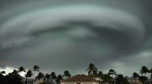
The eye of a hurricane presents a striking contrast to the violent conditions that surround it. Within this circular or oval region, typically spanning 20 to 50 kilometers in diameter, the atmosphere exhibits remarkably calm conditions compared to the surrounding tempest.
The hurricane dynamics create a unique environment where sinking air warms and clears, resulting in light winds and minimal cloud cover. Clear skies above are a hallmark feature as clouds dissipate in the eye's descending air mass.
The internal structure of the eye is characterized by the lowest atmospheric pressure in the system, while the adjacent eyewall structure contains the storm's most intense winds and precipitation.
This remarkable phenomenon occurs due to complex interactions involving the Coriolis force, which deflects winds away from the center, and the presence of high pressure at upper levels causing descending motion.
The eye maintains a delicate balance through continuous processes of convergence and divergence, where air flows inward at lower levels and outward at higher altitudes, sustaining the hurricane's organized circulation.
The Misleading Calm: Hidden Dangers in the Eye

Despite its serene appearance, a hurricane's eye presents life-threatening risks that can deceive those who encounter it. This atmospheric phenomenon, characterized by clear skies and relative tranquility, represents one of the most dangerous hurricane myths: the assumption of safety within the eye.
Understanding storm behavior is critical for survival, as the eye's deceptive calm can shift to catastrophic conditions within seconds. Hurricane hunters confirm that penetrating the eye requires passing through intense rising air in the eyewall.
Three primary dangers exist:
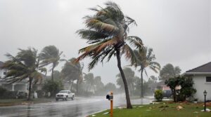
- Immediate proximity to the eyewall, containing the storm's most intense winds exceeding 150 mph
- Rapid deterioration of conditions when moving from eye to eyewall
- Formation of massive waves within the eye due to colliding wind patterns, particularly hazardous at sea
The relationship between eye characteristics and storm intensity remains consistent: stronger hurricanes typically feature smaller eyes, while the surrounding eyewall exhibits more powerful winds.
This inverse correlation underscores why the eye's apparent tranquility should never be interpreted as an indication of safety.
Critical Safety Measures During the Eye's Passage

Implementing critical safety measures during a hurricane's eye passage remains essential for survival, as this deceptive period of calm typically lasts 20-40 minutes before violent conditions resume.
Storm preparedness protocols mandate staying indoors, particularly in interior rooms away from windows and doors, despite the apparent tranquility outside.
Essential eye safety measures include wearing appropriate protective equipment when necessary, such as safety glasses with side shields or goggles, especially if emergency repairs become critical during this brief interval. Resources from Prevent Blindness organizations assist communities with eye protection guidance during severe weather events.
Emergency kits should contain vision-related supplies, including spare glasses, contact lenses, and required medications.
First aid preparations must include knowledge of proper eye injury treatment protocols, such as gentle rinsing with clean water for debris exposure and applying sterile dressings when needed.
Maintaining vigilance during the eye's passage requires monitoring weather updates and adhering to evacuation orders if issued, while keeping emergency contacts and first aid supplies readily accessible.
Understanding Eye Formation and Storm Intensity

Hurricane eye formation marks a critical phase in tropical cyclone development, characterized by increasing storm organization and intensification. The process involves complex storm dynamics where convection forms a ring around the circulation center, establishing an upper-level anticyclone that induces air descent in the center, creating the distinctive eye structure.
Key characteristics of hurricane eye development include:
- Formation typically occurs when wind speeds reach 80-85 knots, accompanied by a significant drop in central wind speed.
- Eye sizes vary dramatically, ranging from 3.7 km to 370 km in diameter.
- The strength of the satellite eye signature correlates with peak eye column warming and subsequent intensity increases.
While eye size alone doesn't determine storm intensity, the standard deviation of the Radius of Maximum Wind provides valuable insight into potential intensity fluctuations. Scientists can detect hurricane eyes using NEXRAD Doppler radar when storms approach coastlines.
During development, eyewall replacement cycles can occur, temporarily weakening the storm before potential re-intensification as the outer eyewall contracts.
Marine Hazards Within the Hurricane's Center

While the eye of a hurricane exhibits relative calm, its surrounding waters present some of the most dangerous maritime conditions known to science. The convergence of waves from multiple directions creates complex wave dynamics, with measurements during Hurricane Ivan revealing wave heights exceeding 40 meters. These marine hazards include erratic wave patterns, deadly rip currents, and severe storm surges that can extend far inland.
| Hazard Type | Characteristics | Impact |
|---|---|---|
| Wave Dynamics | Convergent patterns | Rogue wave formation |
| Storm Surge | Coastal flooding | Infrastructure damage |
| Rip Currents | Strong outward flow | Maritime navigation risks |
| Tidal Effects | Enhanced water levels | Coastal erosion |
| Eye Conditions | Deceptive calm | False safety perception |
The eye's deceptive calm can lead to catastrophic consequences for vessels, as rapid wind changes occur when moving through the eyewall. Storm-induced currents contribute to severe coastal erosion, while saltwater intrusion affects estuaries and wildlife habitats. Multiple eyewalls and eyewall replacement cycles further complicate maritime safety considerations. The central dense overcast can completely obscure the eye, making it difficult for ships to determine their precise position within the storm system.
Common Misconceptions About Hurricane Eyes

The eye of a hurricane creates a deceptively tranquil environment that can mislead people into believing the storm has passed.
This misconception about safety during the eye phase is particularly dangerous, as the calm conditions are temporary and will be followed by the violent winds of the opposing eyewall.
The contrast between the eye's serenity and the surrounding eyewall's intensity represents one of the most hazardous scenarios in hurricane safety, where false perceptions of security can lead to critical lapses in judgment. To protect against unexpected debris during these conditions, experts recommend wearing safety eyewear during all storm preparations and response activities.
Deceptive Calm During Eye
Deceptively peaceful conditions within a hurricane's eye create dangerous misconceptions about safety during these powerful storms. Understanding hurricane dynamics reveals that the eye's calm atmosphere, characterized by low pressure and clear skies, provides false security to those in its path. Due to warm air rising, these systems form over tropical waters near the equator to create their distinctive eye structure.
Key features of the eye's deceptive nature include:
- Variable diameter ranging from 5 to 120 miles, typically measuring 20-40 miles across
- Surrounding eyewall containing the storm's most intense winds, often exceeding 150 mph
- Rapid shift from calm to extreme conditions as the eye passes
The eye's clear conditions mask its role as an integral component of the hurricane's structure. Despite appearing tranquil, this region remains an active part of the storm system, surrounded by the most dangerous and destructive forces within the hurricane.
False Safety Perceptions
Common misconceptions about hurricane eyes present significant public safety risks, leading many to underestimate these powerful storm systems. Several hurricane myths perpetuate false safety perceptions, particularly regarding the eye's deceptively calm conditions.
While the eye may feature clear skies and reduced winds, this temporary respite occurs within a highly dangerous meteorological phenomenon. Wearing proper safety eyewear is critical when venturing outside during any phase of a hurricane due to potential flying debris.
The eye's diameter, which can range from 20 to 120 miles, often misleads people about safe exit timing from shelters. Scientific evidence demonstrates that the eye's low-pressure environment, though less turbulent than the surrounding eyewall, remains hazardous.
Environmental threats persist throughout the hurricane's duration, including contaminated floodwaters, downed power lines, and structural instability. Understanding these risks is essential, as the returning eyewall brings renewed intensity of destructive winds and precipitation.
Eye vs. Eyewall Danger
While hurricane eyes exhibit relatively tranquil conditions, understanding the stark contrast between eye characteristics and eyewall dynamics remains critical for public safety. The deceptive calm within the eye masks the surrounding dangers of intense eyewall dynamics, where storm intensity can exceed 140 miles per hour.
Key contrasts between eye and eyewall conditions include:
- Air pressure: Low-pressure eye center vs. intense pressure gradients in eyewall
- Wind speeds: Light winds in eye vs. destructive eyewall winds from multiple directions
- Structural behavior: Clear skies in eye vs. powerful thunderstorms and mesovortices in eyewall
The eyewall's potential for rapid intensity changes through contraction or replacement cycles makes it particularly hazardous. Typical eye diameters range from 30-65 kilometers across, though size can vary significantly with storm intensity.
Understanding these dynamics is essential, as the right-front quadrant typically exhibits the most destructive conditions in Northern Hemisphere hurricanes.
About The Public Claims Adjusters Network (PCAN)

The Public Claims Adjusters Network (PCAN) operates as an extensive insurance claims management organization, providing expert adjuster services for both residential and commercial properties.
Their catastrophe experts understand that unlike the intense eyewall conditions, hurricane eyes feature relatively calm conditions with light winds. Their network expertise encompasses disaster recovery planning, emergency services, and thorough damage assessment utilizing industry-leading software for precise evaluations.
Public adjusters within PCAN deliver specialized claim assistance, focusing on maximizing client benefits through strategic insurance negotiation. Their expert representation typically achieves a 300-400% increase in claim payouts compared to unassisted claims.
The organization operates on a contingency fee basis, offering free initial consultations and support throughout the entire claims process.
PCAN's thorough services include emergency mitigation, temporary housing coordination, and meticulous claim filing documentation.
Their rapid response capability guarantees on-site assessment within hours of notification, while their CAT adjuster network provides specialized support during catastrophic events, guaranteeing ideal outcomes for both residential and commercial property claims.
Frequently Asked Questions
Can Animals Sense When They're in the Eye of a Hurricane?
Animals possess remarkable sensory capabilities that enable them to detect their position within a hurricane's eye. Through sophisticated animal instincts, various species can perceive changes in barometric pressure, infrasound frequencies, and atmospheric conditions characteristic of hurricane behavior.
Birds, sharks, and other creatures utilize specialized physiological adaptations to recognize the distinct environmental signatures of the eye, including its calmer winds and clearer skies.
How Do Hurricane Hunters Safely Navigate Through the Eye?
Hurricane hunters employ sophisticated navigation systems and safety measures to traverse the eye. They utilize NEXRAD Doppler radar, satellite imagery, and weather instruments to pinpoint the eye's location and track atmospheric conditions.
Pilots monitor wind speed fluctuations and maintain constant communication with ground control. Aircraft operations include specific flight patterns designed to safely penetrate the eyewall while collecting critical meteorological data through specialized onboard equipment.
Does Air Temperature Change Significantly Inside a Hurricane's Eye?
Inside a hurricane's eye, temperature variations are significant and reveal vital aspects of hurricane dynamics.
The eye temperature can be up to 21 degrees Fahrenheit warmer than surrounding air at approximately 3.5 miles altitude. Above 7.5 miles, temperatures rapidly decrease to match the external environment.
These thermal gradients are key indicators of storm intensity, with larger temperature contrasts typically signifying stronger hurricanes.
Can Multiple Hurricanes Share the Same Eye?
Multiple hurricanes cannot share the same eye during normal hurricane formation. Each hurricane develops its own distinct eye characteristics through its unique cyclonic circulation.
When two hurricanes interact, they either maintain separate eyes while rotating around each other (Fujiwhara Effect) or, more commonly, the stronger system absorbs the weaker one, resulting in a single eye structure.
Double eyes only occur temporarily during eyewall replacement cycles within individual storms.
Do Hurricanes Always Maintain the Same Eye Throughout Their Lifetime?
Hurricanes exhibit remarkable variability in their eye dynamics throughout their lifetime.
The storm's eye frequently undergoes structural changes, particularly during eyewall replacement cycles. During these events, a new eyewall forms outside the original one, eventually replacing it completely. This process results in a different eye configuration, often larger but more stable.
Multiple replacement cycles can occur during a single hurricane's existence, each producing distinct eye characteristics.
References
- https://en.wikipedia.org/wiki/Eye_(cyclone)
- https://www.ipcc.ch/site/assets/uploads/sites/3/2019/12/SROCC_FD_GovernmentReviewComments.pdf
- https://preventblindness.org/eye-safety-for-hurricane-preparation-and-storm-damage-cleanup/
- https://batch.libretexts.org/print/Letter/Finished/human-170479/Full.pdf
- https://news.umiamihealth.org/en/eye-safety-during-hurricane-season/
- http://ww2010.atmos.uiuc.edu/(Gh)/guides/mtr/hurr/stages/cane/eye.rxml
- https://en.wikipedia.org/wiki/Eyewall_replacement_cycle
- https://www.wonderopolis.org/wonder/where-is-the-eye-of-the-hurricane
- https://www.worldatlas.com/natural-disasters/what-is-the-eye-of-a-hurricane.html
- https://www.youtube.com/watch?v=F-OSPFQ2XTc